
Published: 10/29/10
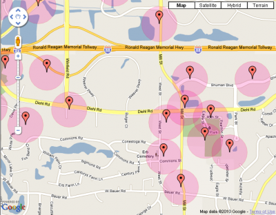
This tool will draw circles of .1 mile radius around a number of waypoints. It can be used to help you find where you can or cannot place a geocache in a given area to comply with the cache saturation rules. As you’re probably aware, these rules require a geocache be no closer than 528 feet from another cache.
In order to use this tool, you must first create one or more GPX files of all caches in the area you’re interested in. A good starting point is the GPX file created by a pocket query on the Geocaching website. Geocaching Swiss Army Knife is useful as well in case you want to add, filter or modify any waypoints. Don’t forget to identify and include the hidden final and intermediate waypoints for puzzle and multi caches. Note: if you include more than 100 or so points, the performance may suffer and the browser my hang while you paste in the GPX text.
Once you’ve got this GPX content, you can use this tool, the Geocache Radius Map, to plot these caches on a map, including shaded circles showing the areas ineligible for new caches.
To get started, launch the application!
Very nice!